This piece is part of a series of articles submitted to The Local Tourist through a cooperation with a 400-level travel writing class at Purdue University.
By Marcus Truscio
I was speeding down a winding, lonely road as the cloud-covered sun set to the west. I stared at my gas gauge, trying to calculate if I could make it back to town the next morning without running out.
A couple minutes later, a Wild West-esque establishment appeared that just so happened to have one vintage gas pump out front like I have never seen before. Before attempting to fill up my tank, I walked into the saloon that was attached to the station to ask if the pump was actually functional.
It was, and they took debit. I felt somewhat embarrassed afterward, feeding into the stereotype as someone from New Jersey who doesn’t normally pump their own gas.
This filling station, a few rental cabins and a motel were the only businesses in the community of Pine Stump Junction. Pine Stump Junction received its name all the way back in the 19th century when logging first started in the Upper Peninsula of Michigan.
It was quite literally a junction of logging roads with a massive pine stump where a mailbox sat for deliveries from Newberry, the nearest town.
Hiking the Upper Peninsula

This was my first time in Michigan’s Upper Peninsula, and I was stunned by how open and wild the landscape was.
Dominated by rivers, lakes, coniferous forests and small towns connected by wide open roads, the region reminded me of places I have been to in northern Maine, where there are more moose than people, or what I imagined parts of Alaska to look like. The only difference was that this outdoor enthusiast’s paradise was located in the Midwest.
Flanked by three of the five great lakes, the landscape of the peninsula has remained relatively unchanged in the last hundred years, with the exception of some of the effects from the logging and mining industries.
Just about as many people live here in 2021 as did in 1921, and even though the peninsula makes up 29% of Michigan’s land area, it only accounts for 3% of the state’s population. This allowed me to step back and focus on getting acquainted with nature on my short break from the responsibilities of the real world.
Day 1: Camping at Muskallonge Lake State Park
During my long weekend adventure, I chose to embrace the outdoors and camp at Muskallonge Lake State Park.
If you like venturing into the outdoors during the day, but prefer spending the night surrounded by four solid walls, the towns of Munising and Grand Marais have a great variety of lodging options.
One perk about visiting a Michigan state park is that they all accept the Recreation Passport. You can purchase the passport at the gates of any state park for $9 per day for out-of-state registration, and $12 for the year for Michigan residents.
With this passport, if you go to one state park, you can get into all of them with the same pass for however long you plan on staying.

Muskallonge Lake State Park has the best of both worlds. The campground at the park sits on the tranquil Muskallonge Lake and has access to all the trails and recreation the park has to offer.
The lake is shallow and flat enough to resemble a mirror, reflecting the thick forest on the opposite shore and enhancing sunsets on clear nights. It is the optimal location for a leisurely kayaking or canoeing excursion.
On the other side of the campground, a short walk just across the road and down the gentle bluff, was the aptly named Lake Superior. I have been to a few other of the Great Lakes, and Superior has definitely earned its title, not only because of its northernmost location, but also because of its vast grandeur and crystal clear water whose waves gently lap against the rocky shore.
After a gray day marked by passing rain showers, I got lucky and the sky gave way to some high clouds and a clear sliver of orange sky that was reflected on the calm waters of Superior just in time for sunset.

Related: find the best places to camp in the Midwest
I went back to camp to sit by the fire. As the sky continued to grow darker, I decided to look up. It had cleared even more and the stars were brilliant. I made the decision to walk back down to Lake Superior to try and get away from any light that the camp was emitting.
As I walked down in the dark, I saw a couple different groups of people sifting through the sand and rocks. One of my friends, Keaton, explained to me how he and his family happen to travel all over the country to rock hunt.
He said Superior is a great place to search for “Yooperlites,” a nickname given to rocks that contain fluorescent sodalite and glow under UV light. I thought it was so interesting how I have never even paid attention to the subculture of rock hunting, yet all of these people descended on this one isolated beach in search of rare rocks.
After learning about Yooperlites, I was reminded of my original motivation for coming down here: the stars. I gave up on caring about getting sandy and laid down on the ground, sandy hair and all. I now was able to comfortably marvel at the natural light show right before my eyes. The Milky Way was right there staring back at me.

Day 2: Hiking Tahquamenon Falls
I usually wake up with the sunrise when I camp and this time was no different, except for the fact that there was no sun and the first thing I heard were raindrops falling onto my tent.
Undeterred by the rain, I hopped in my car and drove about 45 minutes to the southeast in pursuit of the second largest waterfall east of the Mississippi: Tahquamenon Falls.
It is second only to Niagara Falls. The name “Tahquamenon” comes from the Native American word used to describe the color of the water, which is the result from the wetlands that feed the river. The falls were made famous by Henry Wadsworth Longfellow’s The Song of Hiawatha in 1855.
Along the drive there, I gazed at the seemingly never-ending forest that was occasionally interrupted by extensive wetlands (the very wetlands that feed the river).
There was a line to get into the park, but it moved quickly and we were on the trail within 10 minutes. I was surprised at the facilities in the park. There was a gift shop, restrooms, picnic tables, paved paths and even a restaurant, Tahquamenon Falls Brewery & Pub.

I snagged a map and headed onto the trail. As I walked, the roar of the falls grew more intense. It was a short walk to a flight of stairs that led to a viewing platform. As the sky cleared, I was mesmerized by the swollen, but lazy, Tahquamenon River as it abruptly plunged over the edge of a 50-foot cliff into the swirling pool below at 10,000 gallons per second.
The sound of the falls was deafening, yet calming. It is moments like these where I remind myself to stick around just a little longer than I think I should, to savor not only the views, but also the sounds, scents and sensations that make this type of experience so exhilarating.
After soaking in my surroundings, I headed back up the stairs and made my way to the River Trail trailhead. The beginning of the trail is marked with intimidating signage, but do not let this turn you away. This trail was not paved but was well cleared and maintained, and as soon as I hopped on, any remaining crowds had vanished.
The trail as a whole begins at the Upper Falls (where I just was) and follows the river for four miles to the Lower Falls (more of a series of rapids). I chose to treat it as an out and back for a total of eight miles, but you can also turn around whenever you want to make it shorter, or go the full four miles and take the shuttle back to the Upper Falls.
The trail begins on a ridge above the river and winds through the forest as it slowly descends down to the river. It flowed lazily as if the enormous falls weren’t less than a mile upriver. The scenery yet again transported me to some sort of last frontier as the river flowed past the trail.

Day 3: Pictured Rocks National Lakeshore
The next morning I woke up early and by the time the sun was peeking out, I was en route with some friends to Pictured Rocks National Lakeshore, arguably the crown jewel of the Upper Peninsula.
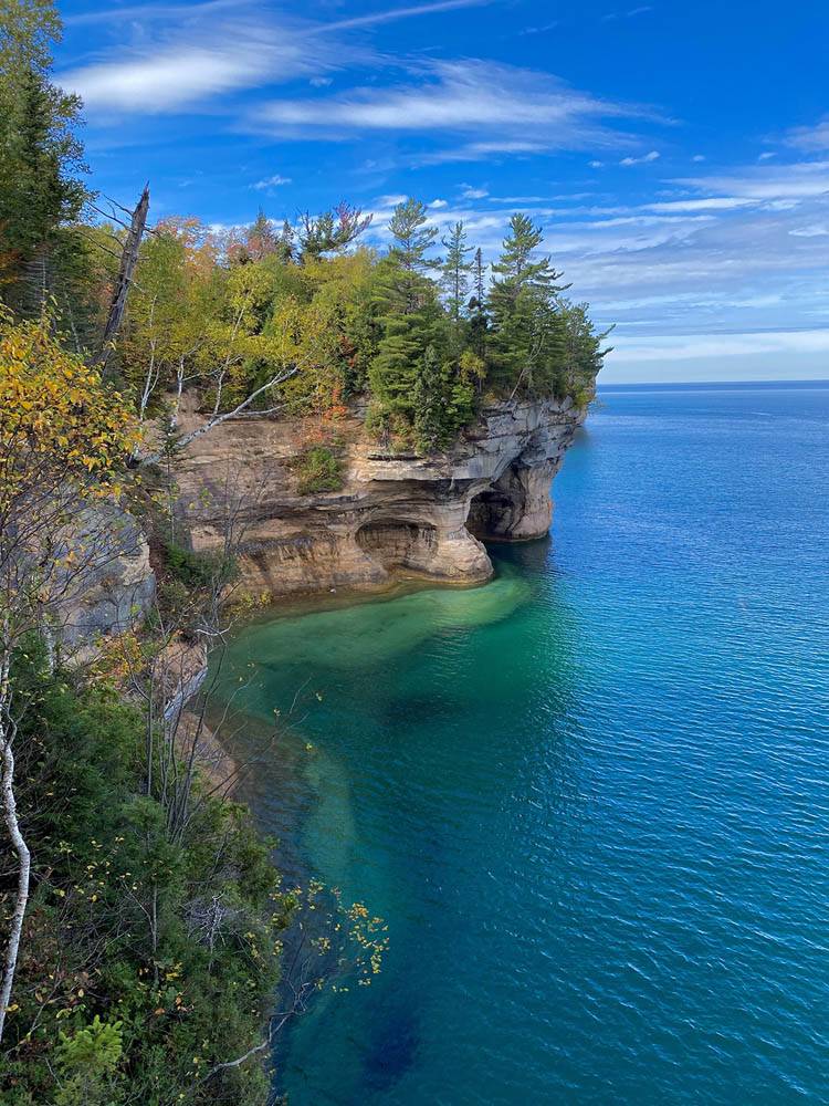
The lakeshore is home to 15 miles of sandstone cliffs up to 200 feet tall, which rise out of Lake Superior and are characterized by caves, arches, blowholes, spires and turrets carved by the waves and weather from the past millennia.
The lakeshore was established as the first National Lakeshore in the U.S. in 1966 and is one of only three today.
We started this day’s hike at Hurricane River within the lakeshore. We spent most of the day zig-zagging along the coast among enormous evergreens while following the North Country Trail westward toward the stretch of towering cliffs known as the Pictured Rocks.
The North Country Trail parallels the coast for 42 miles throughout the entirety of the lakeshore, and is just a section of the North Country Trail System that stretches from Vermont to North Dakota, connecting the Appalachian Trail to the Lewis and Clark Trail.

This particular section of the trail, preceding the Pictured Rocks, traced Twelvemile Beach, a long wide beach bordered by dunes, bluffs and forests. This section was a relaxed and leisurely hike on mostly flat ground that was cushioned by pine needles and moss. The trail was also completely devoid of crowds. As a matter of fact, we only saw two groups all day.

Toward the end of the day’s hike, what seemed like an ordinary turn revealed an entertaining surprise: a car.
A car may not seem too exciting but this was a vintage car that was in the middle of the woods, miles from the nearest road and nestled between the pine trees.
The more I thought about it, the more fascinated I was. How did it get there? How long has it been there? We spent a good 20 minutes taking pictures of the car, peering inside and reading the carvings etched into the paint. The earliest writing I could find was dated 2008, but something told me it had been there far longer than 13 years.

We continued from the car for less than a mile and arrived at our new home for the night, Trappers Lake. We chose to hike into our site, but if that is not your thing, there are plenty of drive up sites throughout the lakeshore.
Muskallonge Lake State Park is also close enough to make several day trips, as well as the towns of Munising and Grand Marais, which are on either end of the lakeshore.
We set up our tents just steps from the water, surrounded by towering pines. After setting up my tent, I set up my hammock on the water’s edge and began reading.
This was one of the most picturesque places I have spent the night. It wasn’t long before the book wound up open on my chest and I dozed off in my hammock.
It also did not take too long for me to wake up and join the rest of my group gathered around the campfire they built. We proceeded to talk for hours. That, I think is often the best thing about traveling with friends old and new, the conversations.
Day 4: Pictured Rocks
The final morning wasn’t marked by rain drops or rays of sunshine falling onto my tent, but instead the sound of distant rumbles of thunder. We quickly packed up and moved out of camp.
Hoping the thunder would stop, we continued westward, heading toward what I later referred to as the “real stuff.” We were slowly ascending and now were beginning to see some rock formations as we became perched above Lake Superior’s waters. I turned a corner and a view to a beautiful cove below opened up.
This was it. The Pictured Rocks.
We headed down into the cove and, quite literally, frolicked on the beach that was surrounded by high, sculpted cliffs on three sides and Lake Superior on the fourth.
When you take the chance to look closer at the rock formations, it seems as if they were created using a massive pottery wheel. The curves, blowholes, mini-caves and layers are all so smooth and uniform and seem to naturally conform to the wave action.


The skies began to clear yet again and from that point on, the cliffs we walked along continued, and with every new turnout from the trail, it seemed every view was more impressive than the last.
The next view I stopped for was when I followed a little sign to a turnout that said “Spray Falls.” I made my way to the ledge and looked up the coast, and a cool view it was, to say the least.
A 100-foot waterfall cascaded into the waters below like a majestic veil. To the right, way off into the distance, was Grand Portal Arch, the most iconic spot in the park and our ultimate destination for the day. I was beyond happy that I decided to stop at this little turnout and now I thought, “Maybe this is one of the most beautiful places I have seen.”

Less than an hour later we arrived at Chapel Beach, a wide sand beach home to the iconic rock of the same name. Chapel Rock had been incredibly weathered over the years but still was home to a lone tree.
The Chapel Loop is a popular day hike, and rightfully so. It starts and ends at the Chapel Beach trailhead and passes through the most scenic stretch of the park. Our group ate the lunch we packed while seated on some driftwood with our toes in the sand watching ultra-blue waves crash ashore.
The waters of Lake Superior here rivaled the water in some Caribbean locations I have been to. As we ate, tour boats from Munising passed by the beach as their passengers marveled at the rocks from a different vantage point.


While finishing up lunch, we had to make a decision. We were tired, but we had to decide whether to take the shorter way straight to the car, or continue along the loop to see some of the most spectacular scenery in the park.
We decided to split up, and even though my feet ached, I decided to complete the longer loop.
As we left Chapel Beach, it was evident that I made the right decision. This section, the Chapel Loop, is the best day hike in the whole park. Along this stretch you can see Grand Portal Arch up close and even stand on top of it. It is where you can get those classic postcard views. We truly saved the best for last.


Finishing this rewarding trail marked the end of my long weekend in Michigan. As I drove along a desolate road toward home, the same as I did on the way in, I reflected on my trip.
Whether I was lying in the sand along Lake Superior gazing at the stars, or going the extra mile on the Chapel Loop, the UP of Michigan fulfilled all of my expectations and more. The scenery left me yearning to come back before I was even home.