
From its start in Red Lodge, Montana, through Beartooth Pass to the northeast entrance of Yellowstone National Park, Beartooth Highway is one of the most scenic drives in the United States.
When compared to epic road trips like Route 66 or the Pacific Coast Highway, Beartooth Highway is a hop, skip, and a jump.
However, don’t let its short mileage fool you. This scenic drive packs a lot into its 68.7 miles through the Beartooth Pass. The late Charles Kuralt called it “the most beautiful drive in America.”
It’s also one of the most dangerous routes.
Reaching an elevation of 10,947 feet above sea level at its highest point, Beartooth Highway winds and wends its way through twenty peaks that exceed 12,000 feet on hairpin curves marked by sheer drop-offs and guardrails that offer the barest illusion of safety.
The weather is mercurial, and, even if the road is open, you never know if you’ll get caught in a blizzard.
And yet, there are glaciers and 10,000 mountain lakes, three National Forests and tumbling streams.
Overlooks that look over ripples of evergreen trees contrast with alpine tundra, and if you look down, if you dare to look down, the snaking blacktop of Depression-era daring.
Is it worth it?

Beartooth Highway is only open during the summer months. As my husband, Jim, and I planned our northwestern United States road trip from Chicago to the Oregon coast and back, we optimistically added “Drive Beartooth Highway” to the itinerary.
We knew full well we might be turned around at Red Lodge.
I anxiously, and frequently, checked the status, relieved when this All-American Road opened three weeks before we were scheduled to drive it.
The date finally arrived. It was early June. We woke up in Billings, Montana, and that evening we’d be sleeping in Yellowstone National Park.
Beartooth Highway is a section of US-212, a road we could have taken directly from Belle Fourche, South Dakota, but if we had, we would have missed Devils Tower and Little Bighorn Battlefield National Monument.
Related: explore even more unique things to do in Montana
While those destinations exacerbated our convoluted, roundabout route, just like our decision the year before to drive around Death Valley so we could ride the oldest electric elevator west of the Mississippi, they were worth the extra miles.
Our Billings to Yellowstone road trip began with a fairly straight course through a flat plain. We neared Red Lodge, Montana, and it looked like the road dead-ended at the big wall of a mountain in our windshield.
Up until 1936, that’s basically what it did. Red Lodge had been a coal mining community, but when the mines closed, the citizens lobbied to have a road constructed through the mountainous terrain from Red Lodge to the first National Park.
President Herbert Hoover signed the Park Approach Act in 1931 and construction on the road began in 1932.
It was the Great Depression, and men lined up to carve a road into the mountains for 50 cents an hour with steam shovels, hand tools, and dynamite. Four years and two and a half million dollars later, the road opened.
Through Red Lodge, US-212 was lined with two-story buildings flying U.S. and Montana flags.
We passed a Carnegie library, a theater marquee advertising handmade chocolates, and a church that looked like a rook, and we barely resisted the urge to stop and explore the historic main street.
We did, however, stop at a wayside exhibit near the end of town.
There, we learned that the Crow who lived in the area before Europeans arrived painted their council tepee with red clay, that “Liver-eating” Johnston kept the peace as Red Lodge’s first constable, and that the Beartooth Plateau was made up of the oldest exposed rocks in Montana and some of the oldest on Earth.

Five minutes out of town the road curved, and curved again, following the swerves of what was now a valley. We climbed higher. Deciduous trees gave way to evergreens.
A creek (crick? spring?) gurgled and cascaded. We pulled over to listen to it for a bit, then hopped back in and continued ascending higher and higher until we reached the open gates telling us that Beartooth Highway was open for business.


Was this “the most beautiful drive in America?” We were about to find out.
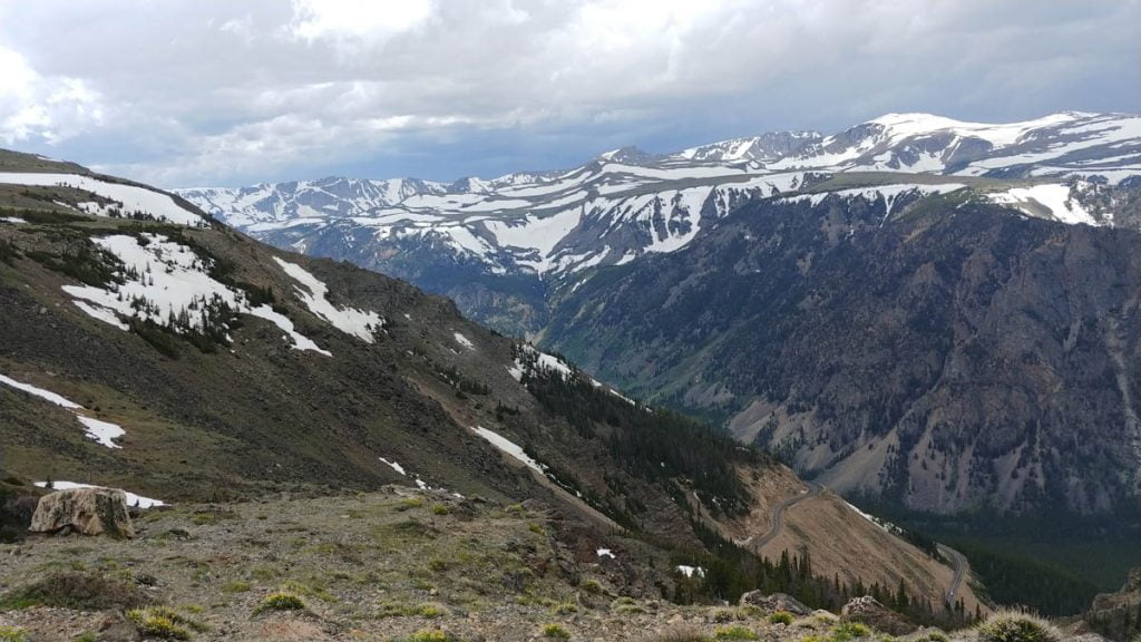
It was a partly cloudy day, and the landscape was random splotches of gray and green with streaks of snowy white.
As we drove higher, the valley got greener and the shoulders got steeper. More rocks, less grass. We followed the switchbacks up up up and could see the mountain peak, where we’d be, eventually.
We pulled over and jumped in the snow, startled when a man wearing ski boots came out of the woods. Driving into higher and higher elevations, there were large swaths with no growth at all, and I imagined an avalanche clearing everything in its path.


The higher we drove, the shorter the trees. Maybe they just seemed shorter, because everything else was beyond a measurable scale.
Melting runoff trickled here and there, feeding the creek we’d left some time ago. It was nearly all brown now. In the high elevation, just a few trees held things in place.
The blacktop, considering its annual freeze and thaw, was in excellent condition and I wondered how often they repaved it.


At 9,190 feet we pulled off at Rock Creek Vista Point. We walked to the overlook and chipmunks scampered. (That’s what they do, right? They scamper?) A raven flew and we looked over the tops of peaks and down down down into the valley below.


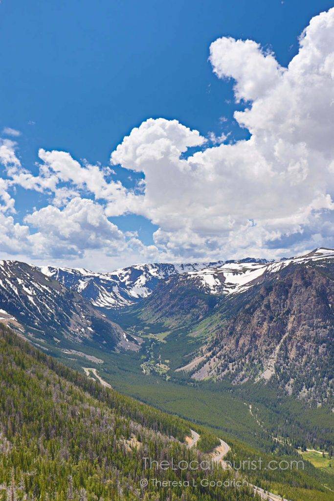

In the distance the clouds grew darker, so we left the scenic overlook and the gorgeous views of Rock Creek Canyon. We continued towards Yellowstone. And climbed up. And up. And up.
Being the passenger, my view was a whole lot of air. There was a guardrail, at least, but I wasn’t sure how much protection it would provide. Thank goodness there wasn’t much traffic and Jim is an excellent driver.
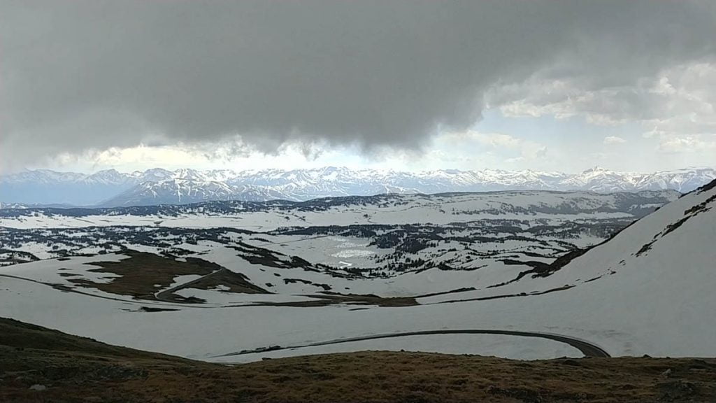
Soon the trees were gone and we were in the clouds, driving between ever-deeper snow banks on the sides of the road.


Stakes lined the shoulder to indicate where the road was supposed to be when the snow covered the pavement completely.
We entered Wyoming again. We drove through a passage where the stakes were completely buried and after a few more turns came across people skiing.
Ah – that’s where that guy had come from.


The darker clouds were no longer in the distance. They were coming in fast, and lightning peppered their approach. We began descending through rain and sleet.

Finally we drove into patches of blue and the storm stayed behind like a petulant child.


With the squall safely behind us, we pulled off at Beartooth Lake.
It was simply breathtaking. Pines stood on half of the opposite shore, and a bare slope and butte rose out of the other, both reflected in the alpine water.


Just past the alpine lake, we crossed a tall bridge and noticed a waterfall. We pulled to the side of the road in front of a few other cars and walked back.
This was unlike any waterfall I’d ever seen, or heard, or experienced. The sheer power overwhelmed the senses. I couldn’t fathom the volume of water pummeling through the canyon lined with pines, and the noise drowned out every other sound.
The current was entirely froth and, despite the onslaught, a tiny tree growing out of a rock in the center held fast.


We hadn’t even gotten to Yellowstone yet, and I could barely speak.
We hiked back to Jeannie the Jeep. Beartooth Highway turned north back into Montana, cut through Cooke City, and 68.7 miles from those open gates, the All-American Road ended and Yellowstone National Park began.
Was it worth it?
You tell me.

Driving Beartooth Highway
Beartooth Highway is the highest elevation highway in the Northern Rockies. The north entrance begins outside of Red Lodge, Montana, enters Wyoming, and ends in southwest Montana again in the historic town of Cooke City.
One of the official National Scenic Byways and one of the most beautiful road trips in the USA, its 68.7 miles is a series of switchbacks through the Beartooth Mountains and Beartooth Pass.
As you’re driving, keep an eye out for the Bear’s Tooth scenic overlook. You’ll be able to see the unique peak for which the pass and the surrounding mountains are named.
From there, it’s a direct line through Silver Lake to the northeastern entrance of Yellowstone National Park.
Along the way, you can take a detour along the Chief Joseph Scenic Byway, which is the only significant intersection along Beartooth Highway.
If you’re a skier, the Beartooth Basin Summer Ski Area is open around mid-June.
The only shop along the Beartooth corridor is the Top of the World Resort.
The road is only open during the warmer months of the year, typically Memorial Day weekend and into October.
However, as I mentioned at the beginning, that can change at any time. Ten days after our drive, a blizzard tore through and closed the road and it was late June. It sometimes snows in late September as well.
Visit the Montana Department of Transportation and the National Weather Service.
Allow two to three hours for the drive, more if you like to stop at every pull-off like we do.
Take it slow; this is definitely about the journey, not the destination!
Places to stay near Beartooth Highway
Lodging is available in Red Lodge and there are several campgrounds in the National Forest.
Read reviews and check rates: TripAdvisor | Booking.com | Agoda
Booking.comPlanning on driving Beartooth Highway? Save this for later!


I have lived in the US my whole life and I’d never heard of this until reading your post! It looks AH-MAZING! Adding it to the road-trip bucket list!!!
It’s definitely bucket list-worthy! Hope you’re able to drive it someday. It’s truly incredible.
This looks like an amazing roadtrip. We really want to get back to the US and do some road trips and hiking. I’ve added this to our list.
This is a great one to include, especially since it ends at Yellowstone!
Woooah it’s like America’s version of the icefield parkway in Canada. I would looove to drive along here (and stop off for hikes along the way!) What beautiful scenery!!
How have I never heard of the Beartooth Highway before? It looks absolutely amazing, although I’m not great driving on dangerous roads. I had to get my now fiance to drive the Road to Hana in Maui because I was a little scared of nudging us off a cliff face.
Thanks for sharing this wonderful experience! I’m looking forward to making this drive with my teenagers this summer. We will need to travel in the opposite direction – from Cooke City to Red Lodge – after visiting Yellowstone. Is there any reason we shouldn’t make the trip that way?
My pleasure! It’s such a beautiful drive. You can absolutely drive it from Yellowstone to Red Lodge!
I’ve traveled a lot in the US and other countries. This is the one thing I’d love to do again. Only this time I’d go slower, make more stops, take more pictures. It’s’ scenery is indescribably gorgeous and the drive, white-knuckled but such fun. Go on a sunny day if possible!